
Yet another duo of backcountry bodies of water named Twin, this pair of pretty, placid lakes sits amidst ancient forests on a high broad plateau east of Oregon’s highest summit. Accessed by following the Pacific Crest Trail for a short distance to a well-maintained trail with not much elevation gain, you can expect these lakes to see a fair amount of visitation. And they do—but, primarily in the summer months when streamlined PCT thru-hikers come barreling by, and over-packed families and neophyte backpackers scamper to choice campsites, and waves of day hikers and equestrians trot by for a visit.
Visit these lakes in mid-fall however and you just might find that you have them all to yourself. Then head over to nearby Palmateer Point for a great view of Mount Hood—and during this time of year, you may very well be sharing that view with no one else. You can do this hike from either the Frog Lake Sno-Park (as described here) or the Barlow Pass Sno-Park just to the north. The distance and elevation gain is nearly identical. And from either direction you can shorten, lengthen or vary the distances.
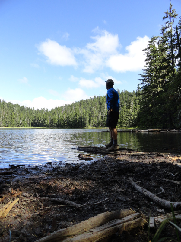
From the Frog Lake Sno-Park, follow the Pacific Crest Trail (PCT) north through a forest of mountain hemlocks, noble firs and silver firs. The wide well-maintained trail climbs a ridge for a gentle 400 feet (122 m) or so as it works its way 1.4 miles (2.3 km) to the junction with the Twin Lakes Trail. Now veer right and descend about 200 feet (61 m) reaching a junction with the Lower Twin Lake Trail at 2.1 miles (3.4 km). Now follow that trail for an easy 0.9 mile (1.5 km) loop around the larger lower lake. You’ll pass campsites set among the big and old trees gracing the lake. On sunny blue sky days, the lake’s waters shimmer. During the heat of summer these waters entice weary hikers to take a dip. If the air is calm, savor reflections of the surrounding ancient forest.
After looping around Lower Twin, head for the smaller and higher Upper Twin. Continue on the main trail climbing a mere 200 feet (61 m) in 0.7 mile (1.1 km) to a junction at the Upper Twin. Be content from this spot with a view of Mount Hood’s frosty summit peaking over the trees—or walk a path circling the small lake.
The way to Palmateer Point veers right. This lightly used trail descends to emerge along a cliff granting good views of Mount Hood and the Barlow Creek Valley below. Continue hiking passing a spur trail leading left back to the Twin Lakes Trail. Then cross Palmateer Creek and soon afterward reach a junction. Now head right for 0.4 mile (0.6 km) climbing 300 feet (91 m) to Palmateer Point, a dry broad knob along the long abrupt ridge you’ve been hiking on. In summer, penstemons and lilies adorn the point. Views are good to Mount Hood and Barlow Butte (an excellent choice for lonesome rambling) across the Barlow Creek Valley below.
Stare down below too to the valley where the historic Barlow Road passed through. The Barlow Road was constructed in 1846 for travelers on the Oregon Trail to bypass the harrowing rapids on the Columbia River below The Dalles. This road however crossing over the Cascades had its challenges too. The meadows to the right share the same name as this point and the creek you recently crossed—all named for a sheep herder who once brought his flocks here. The meadows to the left, Devils Half Acre Meadow were the result of early emigrants setting fires to clear downed trees and brush.
After soaking up the views, return to the Palmateer Trail and head right. Stay left at a junction where a trail leads 0.9 mile (1.5 km) right to Devils Half Acre Meadow. Then at 1.6 miles (2.6 km) from the Upper Twin reach the PCT. From this spot it is 1.5 miles (2.4 km) north to Barlow Pass. You want to head south (left) following this well-traveled trail passing the Twin Lakes Trail and returning to your start at 3.3 miles (5.3 km).
Craig Romano is an award-winning author of more than twenty hiking guidebooks, including Day Hiking Columbia River Gorge (Mountaineers Books).
Above: 1. Views of Mount Hood from Palmateer Point, not far from the Barlow Road used by early settlers coming west via the Oregon Trail. 2. Twin Lakes is accessed by hiking a short portion of the Pacific Crest Trail through a forest of mountain hemlocks, noble firs, and silver firs.
Location: Barlow Pass, Mount Hood National Forest
Distance: 9.4 miles (15.1 kilometers) roundtrip lollipop loop
Elevation gain: 1,600 feet (488 meters)
Difficulty: moderate
Trail notes: Northwest Forest Pass or Interagency pass required (from Nov 1 through Apr 30, an Oregon Sno-Park Pass is required) Dogs permitted on leash. Trail partially in Mount Hood Wilderness—wilderness rules apply; Practice Leave No Trace principles.
Trail highlights: gentle hike to a pair of placed lakes in old-growth forest east of Mount Hood. Then a moderate hike to a clifftop viewpoint of historic meadows below and Mount Hood to the west.
Contact: Mount Hood National Forest
Getting to the Trail: From Portland follow US 26 east to junction with SR 35 near Barlow Pass. Then continue east on US 26 for 4.2 miles (6.8 km) to Frog Lake Sno-Park near Wapinitia Pass.
All photos courtesy of Craig Romano.
If you found this article informative, please consider becoming a supporting reader of Cascadia Magazine. We depend on the generous financial support of people like you to pay our writers and photographers a fair rate for their work. You can make a contribution by visiting our donate page.
And if you’re already a supporting reader, thank you!