
This is a challenging and invigorating snowshoeing destination–you’ll stand atop a 5,271-foot (1607 m) peak just north of Mount Rainier and bask in sweeping, jaw-dropping views of deep emerald valleys and waves of frosty summits. Mount Rainier steals the scenic show here. But once you wrestle your eyes from its spellbound grip, you can also savor the beauty of the nearby recently-scorched Norse Peak Wilderness peaks. Savor too the nearby Clearwater Wilderness peaks, the distant Olympic Mountains, Mount Stuart, and even Mount Baker on the northern horizon. And of course Sun Top’s fire lookout (built in 1933) will no doubt captivate you as well.
In the summer and autumn months, Sun Top’s summit is easily accessible by a gravel Forest Service road. Mountain bikers, hikers, and trail runners can also reach the historic and scenic lookout via a trail that traverses the long ridge to the south of the mountain. When winter casts its snowy blanket upon Sun Top, the Forest Service gates the road in the valley below, allowing skiers and snowshoers a crack at this mountain. By way of the road, the trip is long and a good challenge—but it’s not overly arduous thanks to its moderate incline.
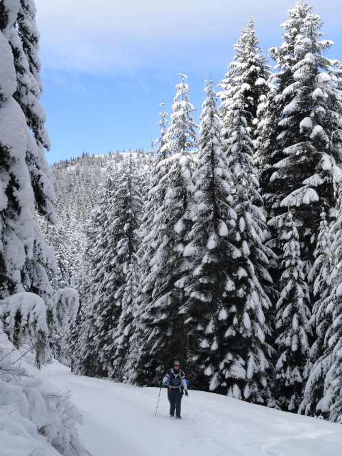
From the Sno-Park, pass the gate and soon come to a junction. The road is a near-level route through old-growth forests along Huckleberry Creek. When the snow level is low it makes for a good family-friendly cross-country skiing trip. But if you want a much better workout and some serous views, head left up FR 7315. The way starts by winding around a Forest Service nursery and undulated between old cuts and patches of mature timber.
The route steadily climbs, never too steeply, but never easing up either. A few good but limited views north and east over second growth forest tease along the way. At 2.2 miles (3.5 km), come to a gate (elevation 3,300 feet/ 1006 m) and a spur road leading right which may tempt you to explore. But unless the weather is bad with no promise of views from above—save this spur for another day, collect your energy, and keep plodding forward and upward.
After making a sharp turn, the route begins wrapping around the fire lookout-graced summit knob, heading for a saddle on its southern ridge. Occasionally look back and catch a glimpse of the semi-open summit. At 5.0 miles (8.0 km), come to the 4,750-foot (1448 m) saddle. Here the road dissects the Sun Top Trail and a spur continues west to a broad shoulder. If avalanche warnings are in place, do not continue toward the summit and consider instead snowshoeing on the spur for limited views.
If the snow is stable continue a short distance on the Sun Top road, soon coming to yet another gate. Do not continue straight on the road as it crosses a steep open slope prone to avalanches. Instead, locate the hiking trail and follow its route switch-backing up the southern slopes of the peak. The forest soon thins and views grow. Reach the summit road at a sharp bend near a solar panel and head right a short distance across the broad open summit.
At 5.5 miles (8.9 km) your journey comes to an end at a fire lookout cabin (one of the few remaining in this region) perched on the 5,271-foot (1607 m) summit. Now, turn around and face south. Wow! Mount Rainier is right in your face—its icy façade nearly blinding. Look west across the deep White River Valley to Crystal Mountain, Castle Mountain, Norse Peak, Pyramid Peak, and Kelly Butte. Then face west, admiring views over the Huckleberry Creek Valley. Beyond its patchwork of logged hillsides are a series of mountains draped in virgin forests protected within the Clearwater Wilderness. Look northward now and scan the horizon from left to right locating the Olympic Mountains, Mount Stuart and Mount Baker. Finally, if the sun is out, savor it on this summit with a fitting name.
All photos courtesy of Craig Romano.
Craig Romano is an award-winning author of more than twenty hiking guidebooks. For details on other great hikes in the Mount Rainier area, pick up a copy of his 100 Classic Hikes Washington (Mountaineers Books).
Location: White River Valley, Mount Baker-Snoqualmie National Forest
Roundtrip: 11.0 miles (17.7 kilometers)
Elevation gain: 3,050 feet (930 meters)
Difficulty: challenging
Trail notes: Sno-Park Pass required; dog-friendly; route is non-groomed and shared with skiers. Beyond the upper gate, the road route crosses an avalanche area that should be avoided during moderate to extreme avalanche warnings and during and after heavy snowfall. Always check current reports at the Northwest Avalanche Center before heading out. This is a challenging route that’s not for beginners. Be sure you have all the appropriate gear and emergency supplies with you.
Trail highlights: historic fire lookout, exceptional views including close ups of Mount Rainier; well-graded non-motorized winter route on Forest Service road.
More info: Mount Baker Snoqualmie National Forest.
Getting to the trail: From Seattle: Take I-5 to SR 167 to SR 410 to Enumclaw; or alternatively Take I-405 to SR 169 to Enumclaw. Then follow SR 410 for 24.6 miles (39.6 km) turning right (just before The Dalles Campground) onto Forest Road 73. Continue for 1.4 miles (2.3 km) to Sno-Park.
.
.
If you found this article useful, please consider becoming a supporting reader of Cascadia Magazine. We rely on the generous donations of readers like you to pay our writers and photographers a fair rate for their work. You can make a contribution at any level you’re comfortable with at our donate page.
And if you’re already a supporting reader, thank you!