
Rooster Rock State Park is better known for its three miles (5 km) of gorgeous sandy beaches on the Columbia River than for the more than five miles (8 km) of trails throughout the park. What many folks might not realize is that the erect basaltic rock for which this park is named after once had a vulgar name. Lewis and Clark camped here in 1805, but didn’t pay much notice to the prominent landmark. But some early settlers named the phallic rock after a euphemism for a male chicken. It was later officially changed to Rooster to be less offensive!
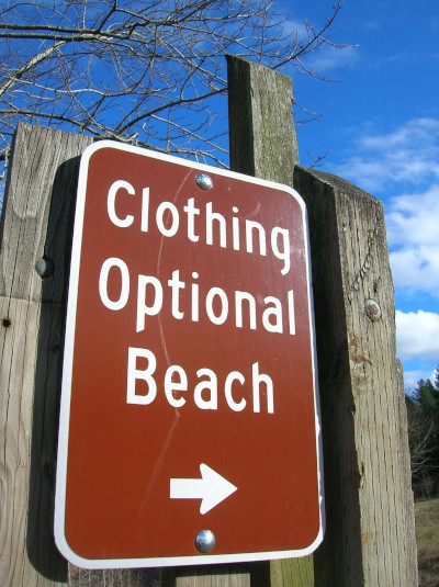
Visitors to the park may now no longer be offended by the rock’s original name, but if they are offended by seeing the original name in public, they may want to steer clear from this park’s lower reaches. Rooster Rock State Park contains one of Oregon’s two officially sanctioned clothing-optional beaches. How apropos! If you follow the trails to the river’s beaches, you’ll need to be bare aware while exploring them!
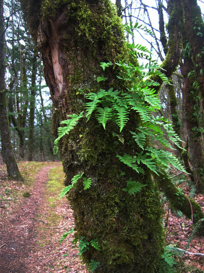
If you’re more interested in hiking (and keeping your clothes on), then head to the 2.8 mile (4.5 km) Forest Loop Trail, taking off from the eastern end of the large parking lot. It quickly enters forest. Avoid veering on to side trails, heading to the park’s Frisbee golf stations for the first .25 mile (0.4 km). The trail then takes to the spine of a small rolling ridge traveling through a lush, attractive stunted forest of oak and maple. Mosses drape the hardwoods while ferns line the way. Winter’s denuded cover allows for window viewing out across the Columbia River to Cape Horn in Washington.
While the trail makes no significant elevation gain, its constant dipping and climbing along the ridge crest means that significant elevation is accumulated on this hike. Trail runners may find this loop quite enjoyable. You’ll pass several intersections that allow you to shorten this loop. You’ll also pass a trail connecting to the .6 mile (1 km) Bluff Trail, which heads to the beach quickly to become a Buff Trail!
The Forest Loop continues on a roller coaster course through hip-high horsetails. At about .9 mile (1.4 km) catch glimpses through the trees of Sand Island with its beautiful dunes. Dunes that during the warmer months are often flush with flesh. At about 1.3 miles (2.1 km) the trail loops back at a nice opening in the forest at the edge of a grassy slope. From this open slope, enjoy the view east of the Columbia River, Angel’s Rest, Beacon Rock and Hamilton Mountain. From here the trail bends westward. More ups and downs and some attractive contorted hardwoods await you. At 2.2 miles (3.5 km) reach the ridge’s highest point (about 190-feet/ 58 m). The way then returns to the Frisbee Golf Course with shortcuts back to the trailhead. The main trail continues straight, dropping off the ridge to a meadow by the highway with good views up to Crown Point. The trail concludes at the Group “A” Picnic Area. From here follow a paved path to the large parking lot and then walk east .3 mile (.5 km) to retrieve your vehicle.
If you want to hike some more, check out Rooster Rock’s “Columbia River Buffs!” The park’s beaches are absolutely stunning. Follow the Lagoon Trail down a staircase to the floodplain. From here a couple of other trails diverge to the river. In summer it’s possible to wade across a channel to the spectacular dunes on Sand Island.
All photos courtesy of Craig Romano.
Craig Romano is an award-winning author of more than twenty hiking guidebooks. For details on this hike and others near Portland, pick up a copy of his Day Hiking Columbia River Gorge (Mountaineers Books).
.
Location: Columbia Gorge National Scenic Area, Oregon
Roundtrip: 3.1 miles (5.0 kilometers)
Elevation gain: 300 feet (91 meters)
Difficulty: easy
Trail notes: Day use parking fee $5.00 (or $30 for an annual pass good for all Oregon State Parks that charge a parking fee); dogs permitted on leash; kid-friendly; historic
Trail highlights: exceptional dunes and Columbia River front access; easy family friendly trail network; uncrowded trails
More info: Rooster Rock State Park
Getting to the trail: From Portland: Follow I-84 east to Exit 25. At .5 mile (0.8 km) pass entrance booth and turn right proceeding .4 mile (0.6 km) to farthest east parking lot. Trail begins to right of restroom at southeast corner of parking lot.
If you found this article useful, please consider becoming a supporting reader of Cascadia Magazine. We rely on the generous donations of readers like you to pay our writers and photographers a fair rate for their work. You can make a contribution at any level you’re comfortable with at our donate page.
And if you’re already a supporting reader, thanks.