The Paradise Ice Caves were one of the most popular features in Mount Rainier National Park. But that was decades ago, before a changing climate claimed this fascinating frozen feature. By the late 1980s the world-famous ice caves were no more. The trail that once lead to them however is still in place—and now it only sees a fraction of the number of hikers than from its heyday. So, hike this trail now for solitude. Its breathtaking close-up views of the mountain and the much smaller now Paradise Glacier are enticing too. There’s also a sparkling tarn along the way, and a slew of waterfalls to keep you mesmerized as well.
The Paradise Glacier Trail branches off from the Skyline Trail at the Stevens-Van Trump Historical Monument. There are several ways you can do this hike, the shortest is by taking the 4th Crossing Trail from the Paradise Valley Road to the Skyline Trail. My preferred route begins at Paradise from the Jackson Visitor Center. Locate the Skyline Trail and head northeast passing the Paradise Inn, and the Guide House and Waterfall trails. Upon cresting a bench just above Edith Creek enjoy a sweeping view of Mount Rainier; and if you’d like, a close-up view of Myrtle Falls by following a short spur trail to the right.
Continue on the Skyline Trail crossing Edith Creek on a bridge and passing the Golden Gate Trail. Then traverse steep slopes across the Paradise Valley enjoying gorgeous views of the valley. The trail descends about 150 feet or so making a boot-wetting crossing of a cascading Paradise River tributary, before making a bridged crossing of another cascading tributary. Here the 4th Crossing Trail departs right. You want to continue left now climbing up Mazama Ridge. Pause to take in magnificent views of Mount Rainier hovering over Paradise.
Upon cresting Mazama Ridge bear left at a junction with the Lakes Trail. Then continue climbing up the open ridge. Views east to Stevens Canyon and beyond and south to the Tatoosh Range are inspiring. So too are the carpets of wildflowers that drape this ridge throughout most of the summer. At 1.8 miles (2.9 km) come to the Stevens-Van Trump Memorial that commemorates the spot where General Hazard Stevens and Philemon Van Trump camped before making their famous 1870 ascent of Rainier. The memorial also commemorates their Native-American guide Sluiskin who waited for their return at this spot. The pretty waterfall just to your left is named for Sluiskin. The canyon to the right is named for Stevens, and a beautiful park above Comet Falls is named for Van Trump. This memorial was placed here in 1921 by the Seattle Mountaineers and Portland based Mazamas.
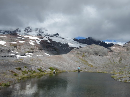
Now head right on the lightly traveled Paradise Glacier Trail ascending a ridge above cascading Stevens Creek. The way grows increasingly open, grasses and sedges giving way to glacial till. The trail is often covered with large snowfields and snow patches throughout the summer. Snow-fed creeks and rivulets rush down and across the trail feeding small tarns and wetland depressions. A series of pretty tarns lie just to the right on the edge of the ridge. When lighting is just right, they capture beautiful reflections of clouds and peaks.
The trail marches north skirting below a small knob before brushing up against a sparkling little tarn that often reflects Rainier. The way then becomes a rockier path traveling along polished ledge and glacial till. This entire area was under a sheet of glacial ice not that long ago. Look around for tenacious marmots scampering about colonizing plants. Look right at the nearby plummeting glacier-fed Stevens Creek.
At 2.5 miles (4.0 km) reach the end of maintained trail. However, when snow is absent, a well-defined path can still be followed beyond. Take it, hiking above and perhaps across a lingering snowfield reaching a barren bench in .3 mile (0.5 km). Here creeks run across this seemingly desolate plain. But look close at the ground and you’ll see mosses and sedges claiming this newly exposed ground. It was here not too long ago where a network of ice caves and the snout of a glacier once reached. The caves are no more and the glacier has receded much higher up the surrounding slopes. It was quite a scene—check out some of the old photos of the caves at the museum in Longmire. The area is still quite beautiful and a testament to our changing climate and environment.
Experienced off-trail hikers can continue farther to check out distant waterfalls. But for most folks—this is a satisfying spot to turn around. Retrace your steps back to the Skyline Trail—and then return the way you came—or consider a longer return by either heading right on the Skyline Trail and following that scenic trail back to Paradise—or by following the Golden Gate Trail back to Paradise—a shorter but just as beautiful return.
All photos by Craig Romano.
Craig Romano is an award-winning author of more than twenty hiking guidebooks, including 100 Classic Hikes Washington (Mountaineers Books) which spotlights the very best hikes capturing the full essence of the Evergreen State.
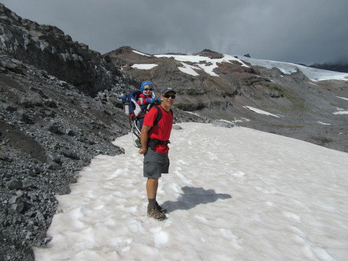
Above: the Paradise Glacier trail at the foot of Mount Rainier offers wildflowers, marmots, and waterfalls — all away from the summer crowds at Paradise.
Location: Mount Rainier National Park, Washington
Distance: 5.6 miles (9.9 kilometers) roundtrip
Elevation gain: 1,000 feet (305 meters)
Difficulty: moderate
Trail notes: National Park Entrance Fee or Interagency Pass; dogs prohibited; practice Leave No Trace principles.
Trail highlights: exceptional views of Mount Rainier, Paradise Glacier and Tatoosh Range; prolific summer wildflowers; waterfalls; historic sites
Contact: Mount Rainier National Park
Getting to the trail: From Tacoma follow SR 7 to Elbe. Then continue on SR 706 east (passing through Ashford) for 14 miles (22.5 km) to the Nisqually Entrance of Mount Rainier National Park. Then continue east on the park’s Paradise-Longmire Road for 17 miles (27.4 km) bearing left onto the Paradise Road. Continue another 2.1 miles (3.4 km) to large parking areas and trailhead.