
Old Glory Mountain is the granddaddy of the rugged Rossland Range located just north of the 49th parallel where the Columbia River exits Canada for the US. Visible from much of Washington’s Kettle River Range and the Selkirk Ranges, this nearly 7,800-foot (2,377 m) prominent peak offers sweeping views of those mountains–as well BC’s Monashee Mountains and Valhalla Ranges. The hike is demanding, but after the initial grunt, views are almost continuous, helping to keep your mind off of the toil.
The route to the summit is via a loop on well-built and marked trails. However, most of the hike is in high country that is open and exposed. In hot weather there’s little shelter from the sun. In inclement weather there’s little shelter from wind, rain, snow, and thunderstorms. Be sure to monitor the weather before setting out. Old Glory and particularly the Big Sheep Creek Basin to the south is bear country–including the occasional grizzly. A few wolverines roam the area too. Although it’s highly unlikely that you’ll encounter these critters, be bear aware.
Start up the Old Glory Trail in a dense old-growth forest reminiscent of the Cascades. In the giant cedars and hemlocks you’ll soon come to a junction with the Plewman Trail. You’ll be returning on that path so stay left on the Old Glory Trail, which utilizes an old road. Cross a tributary of Hanna Creek. Then climb in earnest on a generally good path. At 2.0 miles (3.2 km) come to a junction with the Seven Summits Trail. This 18.5-plus mile (30 km) trail is legendary among mountain bikers, so expect to encounter a few over the next stretch of trail.
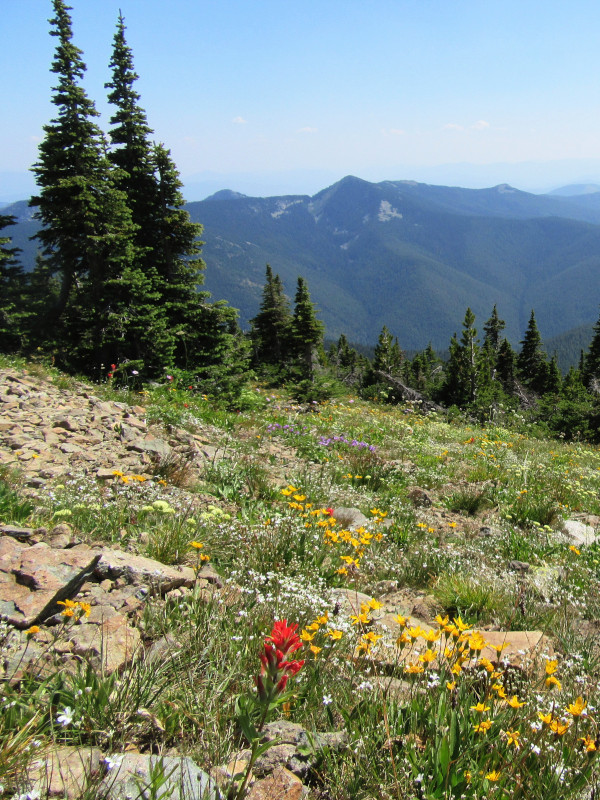
Head right and carry on through thinning forest and along granite ledges and wildflower-saturated meadows. Old Glory with its precipitously-perched summit fire lookout cabin is soon revealed. Continue climbing, traversing meadows of swaying grasses, dancing flowers and whistling silver snags. The broad Big Sheep Creek Basin spreads out directly below you. After more than two miles (3 km) of glorious ridge hiking, reach a junction at 4.3 miles (6.9 km). Now head left on the Old Glory Trail passing signs heeding you to mind the weather.
The trail to Old Glory drops 250 feet (76 m) off of the ridge to round the summit block from the south. En route pass through a high basin ringed with tenacious old trees. Cross a creek at the base of a big talus slope. Then climb steeply. The trail rounds a ridge and heads up Old Glory’s broad south face. Traverse meadows and alpine tundra, coming to a set of ruins just below the summit block. Here, between 1942 and 1968 stood a weather observation station, the highest in Canada at the time. It burned in January of 1968, leaving the attendant technician stranded in the peak’s non-winterized fire lookout cabin. A rescue party braved treacherous winter conditions to safely bring him down off of the mountain.
Now continue just a little farther on a stretch of trail blasted into a ledge and reach the restored fire lookout on Old Glory’s 7,795-foot (2,376 m) summit. The views are horizon-sweeping and stunning. To the northwest is Mount Gladstone. The Valhalla Peaks pierce the northern sky. To the southwest locate Washington’s Kettle River Range. To the southeast, Washington’s Abercrombie Mountain and Hooknose Mountain loom high above the countryside. Look east to the Selkirk Ranges and straight down to the city of Trail on the Columbia River. Locate Nancy Greene Lake twinkling in the Rossland Range. The lake is named for Rossland resident and Olympian Greene, one of Canada’s greatest skiers. And of course admire (and stay back from) the sheer 1,000-foot (305 m) drop off of the peak’s north face.
After you’ve soaked as much scenery as you can handle, retrace your route back to the previous trail junction. Then turn left on the Seven Summits Trail and after a short climb reach a junction with the Plewman Trail. Take this trail right, switchbacking through a high basin flush with meadows before dropping into lush old-growth forest with some impressive cedars. The way then makes three bridged creek crossings before returning to the Old Glory Trail. Your vehicle lies just to the left. Revel in your new glory of hiking Old Glory.
All photos courtesy of Craig Romano.
Craig Romano is an award-winning author of more than twenty hiking guidebooks, including Best Hikes with Dogs Inland Northwest (Mountaineers Books), which includes many trails within British Columbia’s Okanagan and Kootenay regions.
Location: West Kootenay Region, British Columbia
Distance: 11.1 miles (17.9 kilometers) roundtrip
Elevation gain: 3,800 feet (1,158 meters)
Difficulty: difficult
Trail notes: Dog-friendly. Be aware of mountain bikes on Seven Summits Trail. Be bear aware. Avoid this trail in bad weather. Practice Leave No Trace Principles.
Trail highlights: exceptional alpine views, exceptional wildflowers, site of historic weather station, and highest summit in the Rossland Range
Getting to the trailhead: From Trail, BC drive BC 22 west for 6.0 miles (9.7 km) to the junction with BC 3B in Rossland. Then turn right and drive BC 3B 6.2 miles (10 km) to the trailhead, located on your left.
If you appreciate Craig Romano’s hiking articles at Cascadia Magazine, please consider becoming a supporting reader. We depend on contributions from readers like you to pay our writers and photographers a fair rate for their work. Find out more at our donate page.