
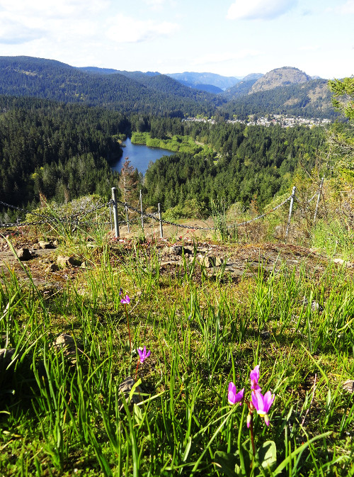
One of the best wildflower hikes in the Capital Regional District on Vancouver Island, Mount Wells also grants some of the area’s best views. Stand atop the worn ledges on this little 1155-foot (352 m) peak west of Victoria, and feast on sweeping views that stretch from Finlayson Arm and the knolled Gowlland Range to Victoria Harbour, the Strait of Juan de Fuca and Washington’s Olympic Mountains.
Don’t be fooled however by this hike’s short distance into thinking this is an easy trail. It’s not. You’ll climb 865 feet (264 m) in less than 1 mile (1.6 km) on steep rocky tread and exposed ledge. The hike can be slick in wet weather and is not recommended for young children. But if you’re sure-footed and looking for an elevated heart rate, carry on!
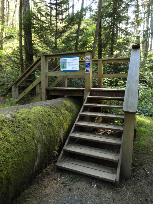
The trail starts near the old Humpback Reservoir which once supplied Victoria with its drinking water from 1915 until the 1990s. Now parallel Humpback Road for a short distance and via stairs climb across an old huge water pipeline. Then cross the road and the pipeline once again—and begin ascending steep slopes sporting an open Douglas fir – arbutus (madrona) forest.
At .6 mile (1 km), the way heads up very steep and rocky ledges that’ll have you using your hands. The old, worn, and striated rock may have you thinking you’re hiking in the Appalachians. Emerge onto polished open ledges lined with lodgepole pine, woolly manzanita, groves of Garry oaks and flowers! The blossoms are brilliant, especially in late spring and early summer. Camas, shooting star and elegant satinflower transform Mount Wells into a purple mountain majesty. Look also for prairie lupine—found nowhere else in Canada. This small lupine favors lowlands and sandy soils and does well in more arid climates. The Olympic Mountain rainshadow and rocky topography here seem ideal for it. Prairie lupines were the first plants to colonize the Mount St Helens blast zone after the 1980 eruption. While most of your attention will be on the ground, take time to look up to the skies from time to time for vultures and raptors.
Railings here help keep you on the trail and from wandering off a cliff edge while also protecting the delicate flowers from trampling. At .8 mile (1.3 km), crest an open area with excellent views of greater Victoria and out to the Gulf and San Juan islands. Soak them up and then continue, dropping into a small saddle, before making the final climb to Well’s 1,155-ft (352-meter) summit.
Savor more sensational views—to the Humpback Reservoir, prominent Mount Finlayson in the Gowlland Range, and Finlayson Arm to the north; and Mount McDonald west in the closed-to-hiking Sooke Hills Wilderness Regional Park Reserve encompassing Victoria’s water supply. The 304-acre (123-ha) Mount Wells Regional Park abuts the 10,131-acre (4100-ha) Sooke Hills Wilderness, and along with the nearby 1179-acre (477 ha) Goldstream and 2965-acre (1200-ha) Gowlland-Tod provincial parks provides for a large greenbelt on the western edge of greater Victoria. Delight in knowing all of those surrounding hills and forests are protected. And embrace the floral beauty at your feet carpeting the summit you’re standing upon.
Photo credits: all images by Craig Romano.
Craig Romano is an award-winning author of more than twenty hiking guidebooks, including Day Hiking the San Juans and Gulf Islands (Mountaineers Books) which includes an entire section on trails in and around Victoria.
Location: Langford, Vancouver Island, British Columbia
Distance: 2.0 miles (3.2 kilometers) roundtrip
Elevation gain: 865 feet (264 meters)
Difficulty: difficult
Trail notes: dogs permitted on leash; please stay on the trail to protect rare plants
Trail highlights: rare wildflowers, sweeping views of the Gowlland Range, Sooke Hills and Victoria Harbour
Contact: Capital Regional District Parks
Getting to the Trail
From Victoria: From Victoria, follow the Trans-Canada Highway northwest for 10.5 miles (17 km) exiting onto the West Shore Parkway. In .2 mile (.3 km) turn right at a roundabout onto Amy Road. Then after .5 mile (.8km) turn left onto Sooke Lake Road. In .2 mile (.3 km) turn left onto Humpback Road and continue for .9 mile (1.4 km) to trailhead.
If you found this article useful and informative, please consider becoming a sponsoring reader. Cascadia Magazine is a non-profit publication that depends on the generous financial support of readers like you to pay our writers and photographers a fair rate for their work. Please visit our donate page to help us continue.
And if you’re already a supporting reader, THANK YOU!