
It’ll still be a few weeks before the high country trails of Olympic National Park’s Hurricane Ridge will be free of snow. If you’re itching to do ridge-roaming on Washington’s Olympic Peninsula right now, look just a little farther west to Olympic National Forest’s Mount Muller. Lower than Hurricane Ridge and with a trail system that has a southern exposure to the sun, the trails here generally melt out by mid-spring. Wildflowers paint the mountain’s meadows by late spring and Muller’s long ridgeline provides a slew of stunning viewpoints. And since it’s located within the national forest, you can bring along your intrepid four-legged hiking companion (dogs aren’t allowed on US national park trails).
It’s a tough climb and an all-day hike if you want to do the mountain’s 12.7-mile (20.4 km) loop. You can shorten the hike a little by doing an out-and-back to the summit or a short loop via the Divide Trail. But these options still involve steep ascents and descents. Consider taking your trekking poles along on this one no matter which route you choose.
I prefer to do this loop clockwise, tackling the steep climb first. The way starts off in a dark damp glen housing Littleton Creek. Don’t be deceived by the initial easy going. The trail soon enough reaches a series of switchbacks that’ll have you climbing 2,000 feet (610 m) in 2.5 miles (4 km). Wind through forest recovering from old cuts and an old fire.
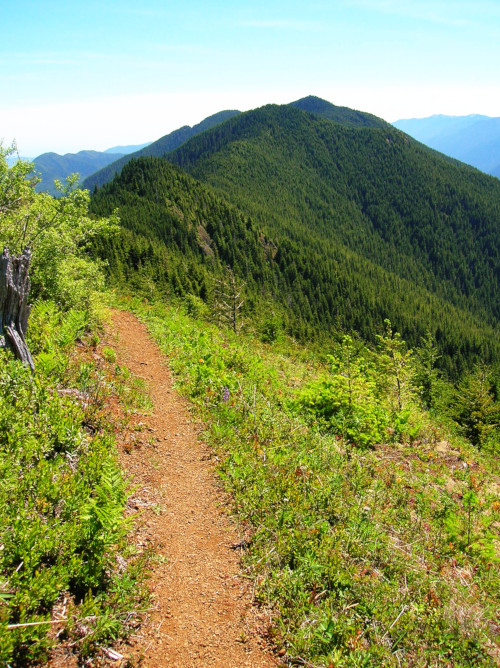
After three long uphill miles (5 km) rejoice as you reach Jim’s Junction on the ridge crest. Here a trail leads left to Kloshe Nanitch; a worthy objective for a return hike. Here too a trail heads straight for a half mile (0.8 km) to a decommissioned forest road. You want to go right, climbing through a stand of silver fir and soon coming to Millsap Meadow. Time to start reaping your scenic rewards. Savor a glorious view of emerald Aurora Ridge; and rising behind it, the massive snow and ice heap of Mount Olympus. The trail then descends four hundred feet to Thomas Gap before steeply regaining lost ground.
The trail then reaches a junction in Jasmine Meadow. Here the Divide Trail, which is sometimes hard to follow, drops off steeply from the ridge to head back toward the trailhead. It offers a shorter loop option or a more direct route to Mount Muller. For Muller continue left through more meadows, pausing to take in views of the Sol Duc Valley below. In late spring and early summer marvel at all the blossoms: paintbrush, tiger lily, thistle, bleeding heart, vetch, star flower, hawkweed, daisy, bear grass, columbine, lupine, strawberry, bunchberry, queen’s cup, and many others.
After hiking 5.5 miles (8.9 km) reach a short side trail leading left for 0.1 mile (0.15 km) to the semi-forested 3,748-foot (1142 m) summit of Mount Muller. Bag it. Then proceed on the main trail to another side path. You’ll want to take this one too. It leads right 0.1 mile (0.15 km) to Panorama Point, a series of outcrops in a sea of meadows. If you think the view can’t possibly get better, wait until you see Lake Crescent sparkling below. Like sentinels, Pyramid Mountain and Mount Storm King guard the fjordlike lake. Mount Baker hovers in the distance.
After soaking up the views, continue up and down along the ridge crest, dashing behind ledges, passing a balanced rock, and undulating between forest and meadow. Then drop rapidly to Mosely Gap, a 2,800-foot (853 m) low point on the ridge. One last uphill, albeit small, struggle awaits you. Then begin a long descent back to the valley.
Be sure not to miss Fouts Rock House, which is comprised of two giant boulders rubbing shoulders. The trail eventually comes to the paved Olympic Discovery Trail (ODT). Head right on it, crossing Hutch Creek on a bridge and shortly afterward veering right back onto single track. Then finish up on a mostly level route returning to the trailhead with 12.7 miles (20.4 km) of hiking completed.
Craig Romano is an award-winning author of more than 20 books. For detailed information on this hike and many others in the region, pick up a copy of his bestselling Day Hiking Olympic Peninsula (Mountaineers Books).
Location: Olympic National Forest
Distance: 12.7 miles (20.4 km)
Elevation gain: 3,350 feet (1021 m)
Difficulty: difficult
Trail notes: Northwest Forest Pass or Interagency Pass required; Dogs permitted on leash; trail open to mountain bikes and horses; Practice Leave No Trace Principles
Trail highlights: spring and summer wildflowers, exceptional views of Lake Crescent, Mount Olympus and Sol Duc Valley
Contact: Olympic National Forest
Getting to the trail: From Seattle, drive to Mukilteo and take the Washington State Ferry to Kingston. Then follow SR 104 west to US 101 and continue west to Port Angeles. Drive US 101 west for 32 miles (51.5 km) and turn right at milepost 216 onto Forest Road 3071 (signed “Mount Muller–Littleton Loop”). Then proceed 0.3 mile (0.5 km) to the trailhead.
If you found this hiking guide useful, consider becoming a supporting reader of Cascadia Magazine.
You can contribute at any level you’re comfortable with at our donate page. Thanks!