
Mount Defiance in Oregon rises nearly one vertical mile above the Columbia River. It’s the highest peak within the Gorge; reaching its summit involves climbing more than 4,800 vertical feet (1,463 m). Used by mountain climbers and trail runners to condition for even bigger peaks—if you succeed in conquering this hulking landmark it’s no little feat in itself.
Despite that Defiance’s summit is defiled with communication towers, the way up and the near summit scree slopes provide gorgeous viewing. And while a much easier and shorter approach to the summit can be made from the south, bragging rights go only to those who tackle this mountain from the river. A loop can be made by utilizing the Starvation Ridge Trail adding some extra distance—well worth it—and advisable to ascend via that trail due to its insanely steep grades.
Start by strolling on a paved path along the busy interstate coming to the Starvation Cut-off, which is currently closed due to a washout. So keep hiking west, soon coming to the Mount Defiance Trail. Head left and come to a cool ravine. Cross Warren Creek on a bridge below Hole-in-the-Wall Falls (created in 1938 by highway workers to divert water away from the old highway) and soon afterward at 0.8 mile (1.3 km) come to a junction. Head left on the Starvation Ridge Trail.
Now climb airy ledges, drop to Cabin Creek and start climbing coming to the closed cut-off trail at 1.6 miles (2.6 km). The trail is rife with poison oak and skirts steep drop-offs, so use caution. The way now crosses a grassy bluff beneath powerlines. It then crests a narrow bluff and heads southward into forest entering the Mark O. Hatfield Wilderness.
Now following a narrow ridge dividing the Cabin and Starvation Creek drainages, sharply climb—insanely steep at times. Trekking poles are a must—so is a heavily caffeinated breakfast beforehand. After crossing a talus slope, the forest transitions to hemlock and soon leaves the wilderness area. Come to a large talus slope granting a good view north to Mount Adams. Soon afterwards, the hike becomes pleasurable as the Starvation Ridge Trail transitions to the Mitchell Point Trail (which no longer heads to its namesake) on an easy grade along a broad ridge. Enjoy occasional views north to Mount St. Helens along the way.
At 4.8 miles (7.7 km) reach a junction. The trail left leads .4 mile (.6 km) to the (gated at trailhead) Mount Defiance summit service road. Don’t be surprised to encounter fresh-faced sweat-free hikers here on their way to Warren Lake. Follow them back into wilderness reaching pretty Warren Lake in .4 mile (.6 km). Set in a bowl surrounded by shiny slabs of scree and lined with vine maples (pretty in autumn) Warren is one of the more picturesque subalpine lakes in the Gorge.
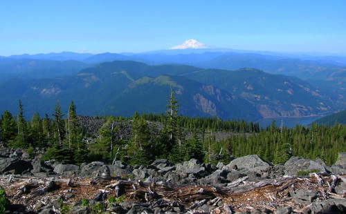
Now clamber over rock toward Defiance’s broad rounded summit. Views north to snowy Washington volcanoes and endless verdant ridges are excellent. Swaying bear grass lines the way as you enter scrappy lodgepole pine forest. At 5.9 miles (9.5 km) reach the Mount Defiance Trail. Now turn left and head up staying left at an unmarked junction—you’ll be returning on the right. Continue through forest crossing the summit road twice and arriving at the less-than-appealing 4,960-foot (1,512 m) summit at 6.6 miles (10.6 km). Congratulate yourself for a noble effort. Then leave the towered summit, following a trail south across shiny scree to a junction. The best views are here and this is where you’ll want to take your much deserved lunch break with Mount Hood staring right at you!
From the junction head right. The trail left drops 1,000 feet (305 m) to a logging road—it’s the easy non-congratulatory way up Mount Defiance. Now traverse several scree slopes beneath the summit, watching your footing and savoring sprawling views. At 7.5 miles (12.1 km), come to the Mount Defiance Trail.
Turn left and begin the long descent. Be sure to bear left in a quarter mile. You don’t want to head down Starvation Ridge. The grade on the Mount Defiance Trail isn’t too bad at first, but gets much steeper the farther you go along. Reaching attractive old-growth forest, the trail wastes little time losing elevation. Pass a couple of excellent viewpoints; then a series of steep switchbacks test your knees for the final descent.
At 11.6 miles (18.7 km) reach a power line swath. The trail turns east here soon passing beneath lovely Lancaster Falls. Just beyond bear left at the Starvation Ridge Trail and follow familiar territory back to your start. Soak your feet upon returning home and relish in your accomplishment!
Craig Romano is an award-winning author of more than twenty hiking guidebooks, including Day Hiking Columbia River Gorge (Mountaineers Books).
Location: Mark O. Hatfield Wilderness, Columbia River Gorge National Scenic Area
Distance: 12.9 mile (20.8 kilometers) loop
Elevation gain: 4,890 feet (1,490 meters)
Difficulty: strenuous
Trail notes: dog-friendly, wilderness regulations apply—practice Leave No Trace Principles
Trail highlights: Highest summit in Columbia River National Scenic Area, sweeping mountain views, summer wildflowers, old-growth, challenging hike
Contact: Columbia Gorge National Scenic Area
Getting to the trail: From Portland follow I-84 east to Exit 55 to the Starvation Creek Trailhead. If coming from the east, you’ll need to follow I-84 to Exit 51 and then double back to Exit 55 because it’s an eastbound exit only.
If you found this article informative, please consider becoming a supporting member of Cascadia Magazine. We rely on the generous financial support of our readers to pay our writers and photographers a fair rate for their work. You can make a contribution at our donate page. And if you’re already a supporting reader, thank you!