
Easily accessible, the Lower South Fork Skokomish River Trail makes for an ideal Olympic Peninsula outing any time of the year. During the rainy season however, this trail allows for extensive hiking when many of the nearby trails are inaccessible due to snow. The river roars when swelled by autumn rains. But the surrounding ancient forest offers a protective canopy, catching the deluge from above and slowly releasing it through mist and droplets. Take note however that this trail and area is prone to flooding—so plan accordingly.
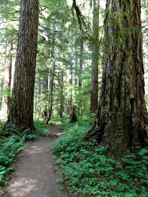
While not protected by wilderness or national park, the lower South Fork Skokomish River valley managed to retain a fair share of its big old growth giants. The well-built trail (also open to mountain bikes and stock) weaves through groves of towering Douglas-firs and glades of massive big leaf maples. During the winter these big trees offer excellent habit for elk. You will most certainly see fresh signs of these large members of the deer family. And a real good chance you might get to see the big beasts as well.
While much of the Lower South Fork Skokomish River Trail heads up the valley at a gentle grade, the trail starts with a good little grunt. From the trailhead, the way steeply climbs about 325 feet over a high bluff. The river is roaring below, but your attention here will be above. The way enters a magnificent old-growth grove of Doug-firs, some more than five hundred years old. You’ll be cocking your head upward admiring these stately giants. Nearing the crest of the bluff, a spur trail heads right to the Le Bar Creek Horse Camp. Soon afterward pass another trail heading right (to an alternative starting point) and then begin to descend. A series of short, steep switchbacks, soon delivers you to the valley floor. Hop across a cascading side creek and then traverse a beautiful glade of mossy maples and alders.
Now head up valley passing more old fir giants, as well as a few stumps of massive cedars that were sent to the mills many years ago. At 1.5 miles (2.4 km) reach a bluff with a great river view; a good destination for a short hike. The trail continues upriver, crossing a side creek in a big-timbered ravine. After walking across a sturdy boardwalk built by the Washington Trails Association, come to a junction with a trail leading to FR 2353-140. Then soon afterwards reach Homestead Camp, once the site of an old ranger guardhouse. A half mile farther you may get your feet wet crossing a side creek in a large outwash. The next creek crossing, however, is via a sturdy bridge.
The trail now ventures slightly up and away from the river, passing some old slides and then dropping back to the roaring waterway and more groves of old growth forest. You’ll need to negotiate several more creek crossings—most of them thankfully by bridge. At 4.5 miles (7.2 km) you’ll reach a junction with a trail leading to FR 2355-100. The short spur to the left leads to the former site of Camp Comfort which washed away from flooding in 2007. Continue straight and soon reach a good river view. At just over five miles (8.0 km) reach an impressive overlook of the river on a bluff high above a big bend where the river has taken away sections of trail in the past. Be careful here admiring the view. This is a good spot to turn around giving you a great workout of more than 10 miles (16.0 km) total.
If you’re compelled to keep hiking beyond the bluff, the trail is lightly traveled and brushy in spots. On an up-and-down course the trail comes to a ford of the river at 8.6 miles (13.8 km). Safely fording the river here can only be done in late summer and early fall when the river’s flow is low. The trail continues beyond the ford and can be accessed by Forest Service roads (seasonally closed for wildlife management).
Photo credits: all photos courtesy of Craig Romano.
Location: Olympic National Forest, Washington
Distance: 10.2 miles (16.4 kilometers) roundtrip
Elevation gain: 950 feet (290 meters)
Difficulty: easy to moderate
Trail notes: Northwest Forest Pass or Interagency pass required; trail also open to stock and mountain bikes; practice Leave No Trace principles.
Trail highlights: lowland old-growth forest, exceptional river views, backpacking opportunities
Contact: Olympic National Forest
Getting to the trail: From Seattle; Follow I-5 south to Olympia. Then drive US 101 north to Shelton. Continue north on US 101 for 7 miles (11.3 km), turning left at milepost 340 onto the Skokomish Valley Road. Follow for 5.6 miles (9.0 km) and bear right onto Forest Road 23. Then drive 9.3 miles (15 km) bearing right onto FR 2353. Continue 0.8 mile (1.3 km) to trailhead.
If you found this article informative, please consider becoming a supporting reader of Cascadia Magazine. We depend on the generous support of our readers to publish great writing and photos from across the Pacific Northwest. You can make a contribution at our donate page. And if you’re already a supporting reader, thank you!