
Back in 1929, Guy and Geraldine Talbot decided to donate 125 acres of their land surrounding a pair of gorgeous waterfalls to the Oregon State Parks system. Guy was president of the Pacific Light and Power Company and was following the lead of several other early area homesteaders and civic leaders to help protect the magnificent Columbia River Gorge. Through subsequent donations and purchases, the Guy W. Talbot State Park now contains 378 magnificent acres.
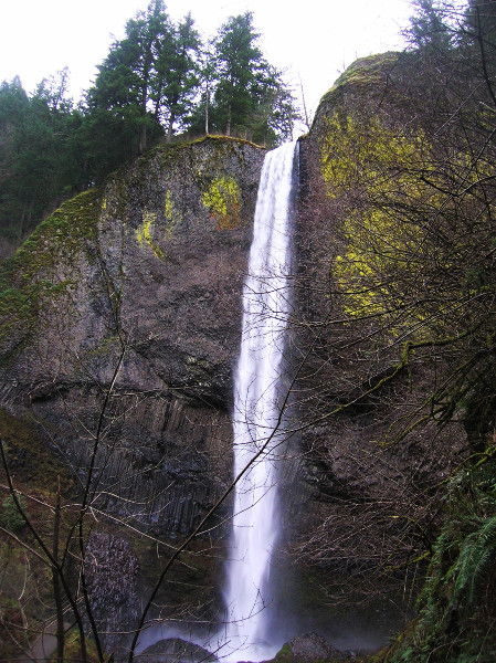
Today the state park’s Latourell Falls (named after an early settler) ranks as one of the most popular hiking destinations within the Columbia River Gorge. Being close to Portland certainly helps Latourell’s visitor numbers—but notwithstanding, these falls, especially the lower one plunging 249 feet over basalt cliffs rank among the most beautiful in the state. Visitation is sure to increase now with many nearby popular trails closed due to damage from the widespread Eagle Creek Fire of 2017. So be sure to treat this place (and all natural places for that matter) with the utmost respect, heeding all rules and regulations and practicing Leave No Trace Principles.
Begin by following a paved path 300 feet to a jaw-dropping viewpoint of the breathtaking lower falls. The majority of Latourell’s spectators only waddle this far. So carry on with your hike and expect some serious crowd thinning. Continue left leaving the pavement and winding upward. Enjoy some different perspectives and a behind the scenes looks at the plummeting cascade. From a bluff above the falls you can also enjoy views out across the Columbia River to Washington’s Mounts Pleasant and Zion.
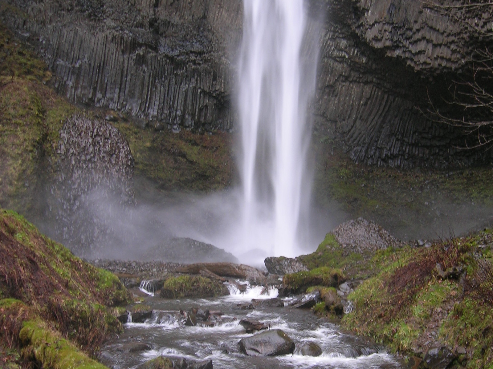
Now, head along Latourell Creek through patches of big firs and moss-draped maples. At about .4 mile (0.6 km) come to a junction. The trail right crosses the creek offering a shortcut to this loop. In winter however, it may be difficult to cross the swollen waterway. The loop continues left working its way into a tight, lush, dank ravine housing impressive cedar groves. With the aid of bridges, cross numerous side creeks before coming to a spray-blasted bridge over Latourell Creek just beneath the 120-foot horsetail-like upper falls. Savor the mist in warm weather. In cooler climes prepare to skedaddle. The curiously-inclined and staying dry-averse may want to get a closer look of the “basalt grotto” behind the falls.
The trail continues, now following Latourell Creek downstream along its west bank. Traversing steep slopes high above the tumbling waterway, gradually descend reaching the shortcut trail. Veer left and climb to the rim of the Lower Fall’s basin. A short spur here leads right to a viewpoint above the falls. Exercise caution and keep children close by.
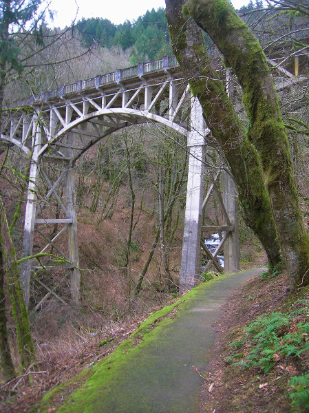
The trail then passes a much safer viewpoint, before switchbacking east at an oddly-shaped and much admired tree. Gradually losing elevation, the trail reaches the Historic Columbia River Highway. Now carefully cross the road here to the park’s picnic grounds and follow a paved trail beside Latourell Creek underneath a 1914-built bridge; one of the historic highway’s few remaining concrete arched bridges. Arrive back at the base of the Lower Falls, one of the most glorious places in the Gorge. Before heading back to your vehicle, stand mesmerized staring at streams of silver water plummeting over an amphitheater of columnar basalt. Then once content, cross the creek and climb back to the trailhead.
For more details on this hike and 99 others in the region, pick up a copy of my Day Hiking Columbia River Gorge book (Mountaineers Books).
 Award-winning author and hiking expert Craig Romano knows the best places to get out and explore. As a guidebook author of 20 books including many in the immensely popular Day Hiking series from Mountaineers Books, he’s the regional authority on hikes for all four seasons, from the Columbia River Gorge to the North Cascades to the Selkirks.
Be sure to check out his author website, and purchase his hiking guides here.
Photo credits: all photos of Latourell Falls trail copyright Craig Romano.
Location: Guy W. Talbot State Park
Columbia Gorge National Scenic Area, Oregon
Roundtrip: 2.3 miles (3.7 kilometers)
Elevation gain: 540 feet (166 meters)
Difficulty: moderate
Trail notes: Dogs permitted on leash; kid-friendly; historic; trail lightly impacted from Eagle River Fire of 2017 and one of the few currently open in the west end of the Columbia River Gorge in Oregon
Trail highlights: exceptional waterfall and closest Columbia River Gorge waterfall to Portland.
Getting to the Trail
From Portland: Follow I-84 east to Exit 28 and proceed .4 mile (0.6 km) to a junction with the Historic Columbia Highway. Turn right (west) and continue 2.6 miles (4.2 km) to trailhead.
If you appreciated this article and found it useful, consider becoming a supporting reader of Cascadia Magazine. We depend on generous donations from our readers to pay our writers, photographers, and illustrators a fair rate for their work. If you’re already a supporting reader, thank you!