
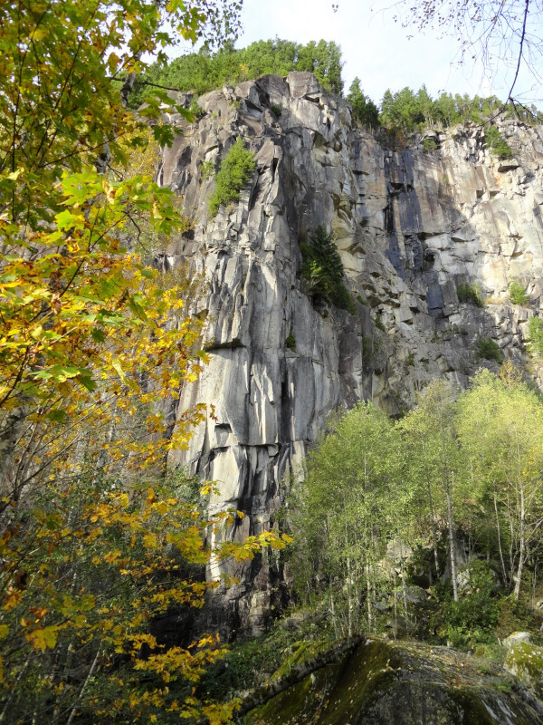
The only natural landmark more stunning than Mount Index, which rises above the little town of Index, Washington, is the Index Town Wall. Forming a 1,200-foot (366 m) vertical backdrop of sheer granite cliffs, the Index Town Wall is imposing and awe inspiring. Renown among climbers for its 50-plus routes and some of the best rock climbing in the Northwest, a not-so-well known hiking trail also leads to its top.
Washington State Parks has acquired much of the wall, guaranteeing public access. The lower sections of the wall were long used as a quarry. About 10 years ago—thanks to a consortium of conservation and recreation groups that included the Access Fund and Washington Climbers Coalition—the old quarry was secured and added to the state park property. The wall is now one of the main attractions of the Forks of the Sky State Park. At more than 1,400 acres (567 Ha), this park protects key riverfront property at the confluence of the Skykomish River and its North Fork. Not just climbers and hikers, but also paddlers, picnickers, and anglers cherish this strip of public land.
From the parking area, walk up a service road and immediately cross (using caution) a set of active railroad tracks. Straight ahead a series of climber paths diverge through a section of the park known as the Stimson Bullitt Climbing Reserve. Continue right on the service road (staying off of the railroad tracks) listening to climbers clambering above. About .25 mile (.4 km) from the parking area you’ll come to a picnic table in front of a big steel door in the cliff face. Behind this door is a 200 foot (61 m) bore created to test a machine used for tunneling under the English Channel.
Locate the trail to the top of the Index Wall to the right of the picnic table at the forest’s edge. While unmarked—it’s obvious. Now begin a steep grunt, ascending nearly 1,300 feet (400 m) in a little more than one mile (1.6 km). The trail is fairly well built though you’ll be marching up steep slopes and ducking under overhanging ledges. The entire way is forested and not exposed. Climbing paths diverge from the main path and you’ll want to avoid these lest you end up in a spot you’d rather not be. Just keep following well-placed arrow signs leading the way.
After 1.2 miles (1.9 km) you’ll reach an old rocky skid road that doubles as a creek bed. Stay to the right of a cable fence and follow this rocky route .1 mile (.16 km) to the top of the wall. Exercise extreme caution approaching the edge of the cliff. Then clutch your heart and catch your breath taking in an absolutely amazing view. Gaze directly below at the town of Index perched on the North Fork of the Skykomish River. Take in the dramatic, cloud-piercing peaks of the Wild Sky Wilderness: Gunn, Merchant, and Baring. Stay for a while fully mesmerized—you earned this view. And as much as this hike was a little challenging, just remember you took the easy way up compared to the routes the climbers take!
Craig Romano is an award-winning author of more than twenty hiking guidebooks. For details on other exceptional hikes in Western Snohomish County, Washington, pick up a copy of his new book, Urban Trails Everett (Mountaineers Books).
Location: Skykomish Valley, Washington
Distance: 2.6 miles (4.2 kilometers) roundtrip
Elevation gain: 1,300 feet (396 m)
Difficulty: moderate
Trail notes: Discover Pass required; dogs must be leashed; steep drop-off, exercise caution especially with children and dogs; practice Leave No Trace principles.
Trail highlights: exceptional views of the Skykomish Valley and Wild Sky Wilderness peaks
Contact: Washington State Parks
Getting to the trail: From Seattle; follow I-5 north to Everett. Then drive US 2 east for 36 miles (58 km). Turn left onto North Fork Road (Index-Galena Road) and continue for 1.0 mile (1.6 km). Turn left onto 5th street. Cross river into Index and proceed to second stop sign turning left onto Index Ave. Follow for .3 mile (0.5 km) (road bends south to become 2nd Street) to stop sign. Turn right onto Ave A and follow .6 mile (1 km) (road becomes Reiter Road) to parking area on right.
If you found this article informative, please consider becoming a supporting reader of Cascadia Magazine. As a nonprofit publication, we depend on the generous financial support of readers like you to pay our writers and photographers a fair rate for their work. Visit out donate page to make a contribution at any level you’re comfortable with.
And if you’re already a supporting reader, thank you!