Not to be confused with a similar-named and equally impressive site on the northern flanks of Mount Rainier, this Glacier Basin sits high above the defunct mining town of Monte Cristo in Washington’s north-central Cascades. It’s a place of rugged breathtaking beauty, where snow-fed braided creeks cascade through mounds of giant talus ringed with showy wildflowers. Reaching this spectacular spot however, is no easy endeavor. The trail leading to it must first be reached by a following an old four-mile (6.4 km) road. Then once on the Glacier Basin Trail, you can expect one of the roughest, rockiest, and steepest trails in the region.
Starting from Barlow Pass, hike or mountain-bike the closed-to-vehicles road to Monte Cristo. At one mile (1.6 km), you’ll reach the South Fork of the Sauk River. It must either be forded, which usually isn’t too difficult late in the summer; or you can go for the nearby log crossing. It’s reached by following a trail a short distance north of the old privy. The log is fairly wide and sturdy, but it crosses a deep pool, so use caution.
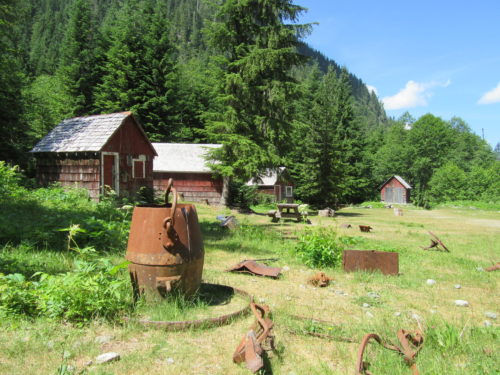
Beyond the river crossing continue another 3.0 miles (4.8 km) to a campground at the edge of the historic Monte Cristo town site. Then cross the South Fork Sauk on good bridge where a handful of have-seen-better-days remnants of a booming town greet you. Cross a creek and reach a grassy flat that once served as a rail yard to Monte Cristo. At its height, this mining town was home to 2,000 people. All that remains now are about a dozen structures and lots of ruins and artifacts. Leave all artifacts in place and respect all private property postings.
Now head to the trailhead for Glacier Basin located near a US Forest Service cabin at the east end of the clearing. Cross 76 Creek on a good bridge and head up what was once Dumas Street, the commercial artery of Monte Cristo. Pass where hotels, brothels, a mercantile, and residences once stood. President Trump’s, grandfather–an immigrant from Germany–Frederick Drumpf was the justice of the peace here for a short stint and ran a hotel that offered more than clean towels (No joke on any of this!)
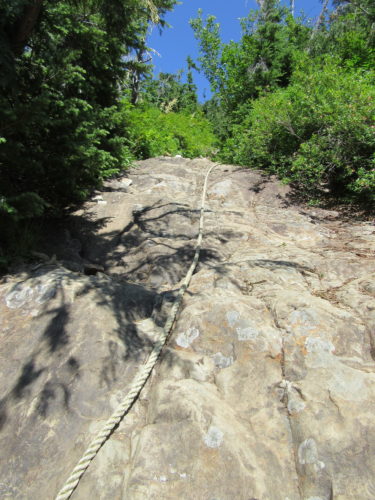
The forest has reclaimed much of the old town. Continue straight at a four-way junction passing old mine sites and eventually leaving forest for avalanche chutes. The trail, which was once a road, heads up an increasingly tighter and wilder valley. It then turns downright mean–heading straight up a worn-to-the-bedrock gully. This is one tough stretch of trail. There is even a section with a rope to aid your ascent.
Take a break at a ledge above a waterfall; then resume climbing. Sanity eventually returns with good tread and an easing grade. Rounding a ridge, Glacier Basin’s guardian peaks come into view. Glacier Creek crashes below through rock and snow, and then disappears under mounds of talus. Now on a near level course, the creek appears once again snaking through willow flats. If the creek allows, continue alongside it on grassy bottomlands. If flooded, pick your way through talus on the original miner’s road. A small cascade marks the entrance to Glacier Basin; a wide expanse of boulders, moraine, snowfields, bubbling creeks, and in summer wildflowers beneath a cluster of jagged ice-adorned peaks. Work your way up to Ray’s Knoll smack dab in the center of the basin, where the trail ends and further explorations just begin–or take a break. Sit down, look around and be totally mesmerized by the rugged and stunning scenery surrounding you.
Photo credits: all photos by Craig Romano.
Craig Romano is an award-winning author of more than twenty hiking guidebooks, including Day Hiking North Cascades (Mountaineers Books).
Location: Henry M. Jackson Wilderness, Mountain Loop Highway, Washington
Distance: 13.4 miles (21.6 kilometers) roundtrip
Elevation Gain: 2,050 feet (625 meters)
Difficulty: strenuous
Trail notes: Northwest Trail Pass or interagency pass required; wilderness regulations apply—practice Leave No Trace Principles
Trail highlights: ghost town, remote cirque above historic mining district, summer wildflowers; solitude, old-growth, challenging hike requiring hands in spots
Contact: Darrington Ranger District, Mount Baker-Snoqualmie National Forest
Getting to the trail: From Seattle: Follow I-5 north to Everett. The head east on US 2 and take exit for SR 204. Continue on SR 204 east to SR 9 in Lake Stevens. Then travel north on SR 9 to SR 92 and follow this road east to Granite Falls. Then follow the Mountain Loop Highway east for 30 miles (48 km) to Barlow Pass. Hike begins by walking up gated Monte Cristo Road.
.
.