
A classic hike in the sprawling 206,756-acre (83,671 ha) Manning Park, Frosty Mountain is the park’s highest summit. One of the more challenging hikes in the park, you’ll be rewarded with breathtaking views across both British Columbia’s and Washington’s North Cascades. Plus, you’ll hike through one of Canada’s oldest forests—a stand of alpine larch (Larix liyallii) with trees close to 2,000 years old. And from mid-September through mid-October these deciduous conifers’ soft needles turn a brilliant gold.
The hike to Frosty Mountain begins from the north end of the Lightning Lake Loop. From the large picnic and trailhead parking area, head off across a large lawn. Then walk across a large earthen dam where water north flows into Little Muddy Creek and then onward to the Simalkameen River. The trail soon afterward comes to the Frosty Mountain Trail near a scree slope where pikas can sometimes be seen and almost always heard.
Now prepare to burn some calories and gain some elevation. The well-trodden trail steadily ascends through a series of switchbacks traversing a mature forest of spruce and subalpine fir. Breaks in the forest canopy allow viewing down to Lightening and Flash lakes in the tight valley below.
The climb can be relentless at times. At about 4.2 miles (6.8 kilometers) you’ll pass a backcountry campsite complete with a wooden shelter that you’ll no doubt share with rodents if you opt to stay in it. Cross Frosty Creek (your last source of dependable water) and continue climbing—the grade eventually easing up. Now enter Frosty’s famous alpine larch forest.
Growing in high elevations in the Northern Rockies of the US, as well as the Canadian Rockies, the alpine larch has a pretty restricted range in the Cascades. Frosty Mountain is its westernmost limit in British Columbia and pretty close to its northern limits in the Cascades. A hardy tree, the stand here, like others in the Rockies, contains trees nearly 2,000 years old. Come late September they turn the upper slopes of this mountain golden. Frosty’s rocky snowy summit provides a striking backdrop to the glowing larches. Respect this fragile environment by staying on the trail. And if you miss larch season, or are looking for a return trip to this locale, plan on a trip in early August when wildflowers paint the subalpine meadows in resplendent colors.
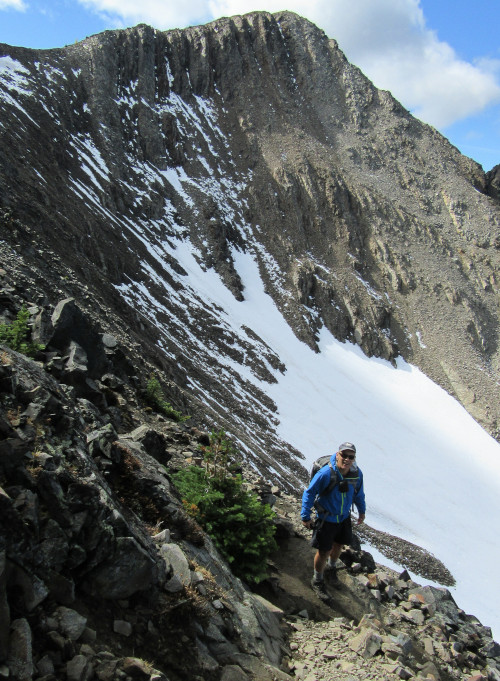
The trail continues higher, leaving the forest for scree and barren rocky slopes. A few larch stragglers tenaciously cling to life in this harsh alpine environment. At 6.2 miles (10 km) reach a junction (elev. 7575 feet/ 2309 meters) high on Frosty’s northern shoulder. Here a trail departs north for the Pacific Crest Trail (PCT) and Windy Joe Trail. Strong hikers can make a long loop by returning on this very lightly traveled trail.
To reach Frosty’s summit, pass the sign warning you to use caution — then cross the barren, rocky ridge. This 0.4 mile (0.6 km) stretch of trail should be avoided in bad weather and when snow covered. The going isn’t too bad at first—but it then makes one last steep climb reaching the 7,900-foot (2408 meter) summit of Frosty’s East Peak. The West peak is actually higher by 49 feet (15 meters0, but it’s strictly a climb. Be content with this high point and its stunning 360-degree views.
Look east to the area along the international border to towering Winthrop Mountain and peaks in the Cathedral Lakes region covering both Washington’s Pasayten Wilderness and BC’s Cathedral Lakes Provincial Parks. Look north to the high meadow country of Three Brothers Mountain—and beyond to broad forested ridges and summits. Look west to Skyline Divide, towering Silvertip Mountain and Mount Outram, and awe-inspiring Hozomeen Mountain which acted as a muse to beatnik poet Jack Kerouac when he was a fire lookout in the North Cascades during the summer of 1956.
Then look south across an isolated little tarn to the serrated peaks of Washington’s North Cascades. Try to locate Jack and Crater Mountains directly south. Mount Baker should be easy enough to identify. When you’ve had enough of this view (which is probably not going to happen)—consider the short daylight hour remaining and start the long hike back to the trailhead. A set of trekking poles will help ease the descent.
Photo credits: all photos copyright Craig Romano.
Craig Romano is an award-winning author of more than twenty hiking guidebooks, including Day Hiking North Cascades (Mountaineers Books), which includes many scenic trails just south of Manning Park in the North Cascades National Park complex.
Location: E. C. Manning Provincial Park, British Columbia
Distance: 13.2 miles (21.2 kilometers) roundtrip
Elevation gain: 3,820 feet (1,164 meters)
Difficulty: difficult
Trail notes: Dogs permitted on leash. Practice Leave No Trace principles.
Trail highlights: challenging hike to highest peak in Manning Park. Stunning North Cascades views and a stand of ancient alpine larches
Contact: E.C Manning Provincial Park
Getting to the trail: From Vancouver follow Trans-Canada Highway 1 east to Hope. Then continue east on BC 3 (Crowsnest Highway) for 37.5 miles (60 kilometers) and turn right on the Gibson Pass Road in Manning Park near the lodge. Continue for 1.8 miles (2.9 kilometers) and bear left driving another 0.5 mile (0.8 kilometer) to large parking area and trailhead.
If you found this article informative, please consider becoming a supporting reader of Cascadia Magazine. We depend on the generous financial support of people like you to pay our writers and photographers a fair rate for their work. You can make a contribution by visiting our donate page.
And if you’re already a supporting reader, thank you!