
Walk upon a perfectly level path along Boundary Bay’s glistening mud and salt flats and be blown away by one of the best avian shows in Cascadia. A globally-recognized IBA (Important Bird Area), Boundary Bay is not far from Vancouver, British Columbia and bursts with migratory and wintering birds during the fall and spring. An important stopover in the Pacific Flyway, Boundary Bay provides habitat for scores of bird species. More than one and half million birds pass through, stop, or stay here.
The 28,342-acre (11,470 ha) Boundary Bay Wildlife Management Area (which the Dyke Trail traverses a good portion of) is part of the larger Fraser River estuary. This estuary supports the largest wintering waterfowl and shorebird populations in Canada. Take a hike here in November and witness thousands of dunlins, western sandpipers, and black-bellied plover. You’ll probably also see brants, mallards, wigeons, and herons. The area is also a great place for seeing raptors: watch for eagles, hawks, harriers, falcons, and owls. Snowy owls, which journey all the way from the arctic, are frequent at Boundary Bay as well. Even though Boundary Bay is well-known among bird watchers, this area also supports plenty of non-feathered species too. Nearly two-thirds of the Fraser Estuary’s harbor seal population lives here. Orcas frequent these waters, too. Definitely pack your binoculars along with your camera.
Any section of this 10-plus mile trail will work for a short hike. But if you can arrange a shuttle and want to go for a long hike, consider doing this trail one-way. There is no parking at the trail’s western terminus, but you can park a short distance from it at Boundary Bay Regional Park (another great hiking and birding spot). There is parking at the eastern terminus of the trail at Surrey’s Mud Bay Park. There are also two short shoreline trails at Mud Bay Park that can be used with the Dyke Trail to form a couple of loops. Note that the shoreline trails are closed to dogs from October 15th to April 15th.
The Dyke Trail heads west from here, paralleling BC 99–note that it can be a little noisy from the adjacent traffic. At 1.4 miles (2.2 km), the trail leaves Surrey for Delta. It continues to run alongside Mud Bay, a smaller bay within Boundary Bay. Enjoy good views across to Blackie Spit and Crescent Beach (another great place for hiking and birdwatching) in south Surrey. After passing the BC 91 interchange, the trail and BC 99 part ways. You will now hear bird song rather than highway buzz.
The trail continues along a dyke, which separates salt and mud flats on the left from agricultural lands on the right. While Delta is home to more than 100,000 residents, it is also home to some of the largest agricultural lands in the Vancouver Regional District. Farm vehicles frequently use the Dyke Trail. Be sure to yield to them and always keep your dog under control as to not interfere with farming operations as well as the sensitive bird areas.
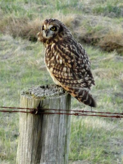
At 3.6 miles (5.8 km) come to the Delta Heritage Airpark Trailhead. Look out into bay here for a large array of pilings. These are the remnants of large oyster farming operations that were discontinued in the 1960s. The trail here continues through a rural landscape along the bay. Watch the bay for shore birds and waterfowl—there will be tens of thousands all along the way. Look up in the overhanging branches of trees for hawks and eagles. Scan the flats for snowy owls and fence posts for short-eared owls. And keep a watch in both the farm fields and bay flats for coyotes.
At 7.8 miles (12.6 km) come to the 72 Street trailhead. Here enjoy some wildlife art sculptures and check out the interpretive panels. At 9.3 miles (14.9 km) come to the 64 Street trailhead. The trail bends south now along the bay. Enjoy good views of Mount Baker to the east and the San Juan Islands to the south. At 10.4 miles (16.7 km) the trail ends at Beach Grove Road in Tsawwassen. If you want to keep hiking, you can follow Beach Grove Road south through a quiet residential area for .7 mile (1.1 km) to Boundary Bay Regional Park, where there are several more miles of good trails, a lovely beach, and of course more excellent birdwatching opportunities.
Photo credits: all photos courtesy of Craig Romano.
Location: Boundary Bay Wildlife Management Area, Surrey and Delta, British Columbia
Distance: 10.4 miles (16.7 kilometers) one way
Elevation gain: minimal
Difficulty: easy
Trail notes: trail is also open to stock and bikes; dogs permitted on leash but note dogs are not allowed on shoreline trail in Mud Bay Park from Oct 15-Apr 15; seasonal bird hunting; Practice Leave No Trace principles.
Trail highlights: One of the best birdwatching areas on the Salish Sea; sweeping views of Mount Baker, San Juan Islands, and BC Coast Range
Contact: Boundary Bay Wildlife Management Area
Getting to the trail: From Vancouver; Follow BC-99 south to Exit 20 (From Seattle, follow I-5 north to BC 99 to Exit 20). Then follow Hornby Drive east for 1.3 miles (2.1 km). Turn right onto 104 Street and drive 0.9 mile (1.4 km) to trailhead parking near Delta Heritage Park. Other trailheads can be found at Mud Bay Park in Surrey and 64 Street and 72 Street in Delta.
If you found this article informative, please consider becoming a supporting reader of Cascadia Magazine. We depend on the generous financial support of people like you to pay our writers and photographers a fair rate for their work. You can make a contribution by visiting our donate page.
And if you’re already a supporting reader, thank you!