
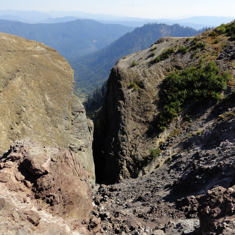
Hike up a forested ridge on Mount St. Helens to the head of the tightly notched and stark Ape Canyon. While the view down this narrow chasm is indeed impressive—it pales in magnitude compared to the nearby Muddy River Lahar. Here during the 1980 eruption, a massive mudflow nearly a mile wide took out nearly everything in its path. But the old-growth forests along the ridge sporting the Ape Canyon Trail survived. This trail is one of most fascinating in the national volcanic monument. It’s also one of the more popular ones—so try for a weekday.
The trail starts off fairly easy, traversing patches of old growth interspersed with tracts of forest that were harvested pre-eruption. The trail is well-groomed and well-traveled, particularly by mountain bikers. It’s one of their favorite routes in the monument, so be aware—keep dogs on a leash and children nearby and alert.
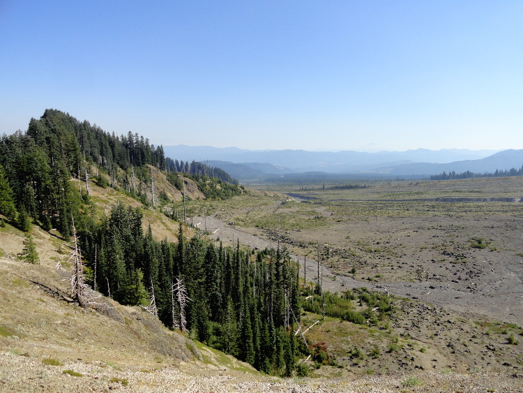
The way follows the edge of a huge lahar. Lahars are giant mudflows or debris flows created by a volcanic eruption. They consist of water, rocky debris, and a slurry of pyroclastic material. The origin of the word is Javanese—and the island of Java in Indonesia is no stranger to volcanic eruptions. The Muddy River Lahar here was formed by the rapid melting of snow and ice on St. Helens’ upper reaches and the Shoestring Glacier during the 1980 eruption. A thick slurry of mud and debris rushed down the mountain, scouring a path nearly one mile wide. Today the Muddy River channels through the gray rubble as colonizing plants slowly bring life back to the swath.
The trail passes several excellent viewing spots of the lahar, then begins to climb more earnestly. Utilizing switchbacks, it marches up the ridge through a gorgeous old growth forest of Douglas-fir, silver fir, noble fir, and western hemlock. Enjoy window views of St. Helens before reaching a good viewpoint of the volcano after about 3.0 miles (5.0 km).
The trail then descends through a tunnel of ancient trees to a small saddle, before resuming to climb. Upward mobility is once again interrupted with a short descent. Then it’s up once again. The big trees yield to snags and downed wood as the trail transitions into a landscape altered by the 1980 eruption. Now on a narrower and more open ridge, enjoy excellent views north to Rainier, east to Adams, and of St. Helens right before you.
At this point Ape Canyon also comes into view. After rounding a knoll housing seismic measuring equipment, the trail skirts the canyon’s rim, coming to a junction with the Loowit Trail at 4.7 miles (7.6 km). Here at the scoured canyon’s upper reaches, the walls are a mere eight feet (2.4 m) apart. It’s quite dramatic, especially when it frames Mount Adams in the distance.
If you’re wondering about the apes, the only apes you’ll see are your fellow hikers. The canyon supposedly received its name back in 1924 after a group of apemen threw rocks at a miners’ cabin in the canyon. The apemen were actually young outdoorsmen who were probably unaware of the cabin. And of course all modern day apemen know never to throw rocks below them from a trail.
If after reaching the canyon rim, you’re still itching for more hiking, continue right on the Loowit Trail, You’ll pass a small waterfall in less than a mile. Beyond that, a spectacular carpet of lupines gracing the Plains of Abraham for a near level mile awaits you.
All photos by Craig Romano.
Craig Romano is an award-winning author of more than twenty hiking guidebooks, including Day Hiking Mount St. Helens (Mountaineers Books) which includes every trail (including backpacking trips and winter trails) within the Mount St. Helens National Volcanic Monument.
Above: The Ape Canyon Trail, one of the most popular in Mount St. Helens National Volcanic Monument, offers a tour through varied landscapes–from old growth forests to barren plains where the effects of the eruption of May 18, 1980 are still visible.
Location: Mount St. Helens National Volcanic Monument, Washington
Distance: 9.4 miles (6.8 kilometers) roundtrip
Elevation gain: 1,550 feet (472 meters)
Difficulty: moderate
Trail notes: Northwest Forest Pass required. Trail is also open to mountain bikes and bike use can be heavy on weekends. Dog friendly. Practice Leave No Trace principles.
Trail highlights: exceptional views of Mount St Helens and the Muddy River Lahar. Impressive stands of old growth, summer wildflowers, and a remarkable canyon.
Contact: Mount St. Helens National Volcanic Monument
Getting to the trail: From Portland follow I-5 north to Exit 21 in Woodland, WA. Then drive SR 503 east for 29 miles (46.7 km) to Cougar. Continue east on SR 503 (which becomes FR 90) for 7.0 miles (11.3 km) turning left onto FR 83. Then follow this road for 11.3 miles (18.2 km) to trailhead.
If you found this article helpful or informative, please consider becoming a supporting reader of Cascadia Magazine. We depend on the generous financial support of our readers to pay our writers and creative contributors a fair rate for their work. Please visit our donate page if you’d like to join the people who make this publication possible.
And if you’re already a supporting reader, thank you!