
First Nations and local residents work to halt the Site C dam project in northeast British Columbia
As the controversial Site C dam project in northeastern B.C. enters its fourth year of construction, one of the last chances of stopping it rests on a legal showdown underway in B.C. Supreme Court.
In August, journalist Alison Bate visited the Peace Region with two friends and talked to long-time residents fighting against the project, including Yvonne Tupper from Saulteau First Nations, farmers Arlene and Ken Boon, and horse breeder Esther Pedersen. She also spoke with West Moberly chief Roland Willson, dropped in on the court case to hear B.C. Hydro’s arguments and finally, visited the dam site itself.
“I still don’t have my cow,” said Yvonne Tupper, at the end of a busy day showing us her favorite the spots in and around the Peace Valley.
She was semi-joking about the cow, of course, but broken treaty promises like this are at the heart of an interim injunction case in B.C. Supreme Court that aims to stop the Site C project. The case resumed on Sept. 4 for the final four days.
We were way up in the northeast of B.C. in a broad valley with an appealing mix of rocky bluffs and fertile farmland; forests of evergreens, birches and poplars; an expanse of wide-open skies—and in the middle of it all a long, curving river that flows northeast through Alberta before emptying into the Slave River.
The Peace River is more than 1,200 kilometres (about 750 miles) from Vancouver, the same distance as it would be to drive from southern B.C. all the way through Washington state and Oregon to northern California.
To get here, we drove through a province choked with haze from forest fires, alongside double-stack container trains winding through the Fraser Canyon and on roads growing emptier with each passing hour. North of Prince George, the traffic thinned out even more, leaving mainly logging trucks, heavy-duty RVs on their way to and from Alaska, and pick-up trucks in a hurry.
We call this the fake river, because it’s coming from the dam.
Tupper, a member of the Saulteau First Nations, met us in Chetwynd, the gateway to the Peace Region, and home to West Fraser’s lumber mill and numerous chainsaw woodcarvings lining the streets.
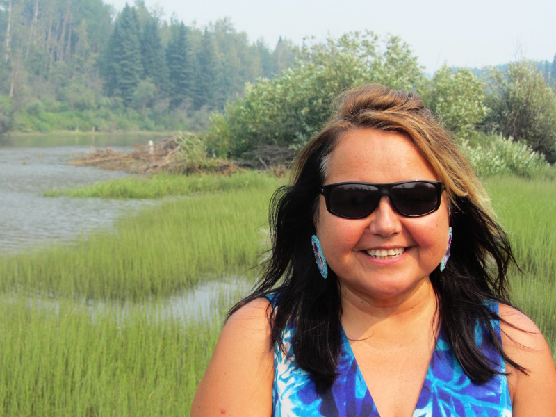
She took us first to see where the Moberly River enters Moberly Lake and pointed to an impressive beaver dam at the mouth of the river. “That’s what dams should look like,” she said.
Tupper has been fighting the other dam—the Site C dam—for many years. “My first knowledge of Site C was when I was ten, 30 years ago. My grandfather told me: “Remember, you must always stop Site C.”
In the 1970s, the site identified as “C,” was noted as the best location for a third dam on the Peace River, after the W.A.C. Bennett and Peace Canyon dams. It’s been a complicated saga ever since.
After showing us around the Saulteau reserve and the Twin Sisters Native Plants Nursery, Tupper took us to one of her favorite spots on the Peace River, just below the Peace Canyon dam. Here, the river swirled past massive sandstone cliffs and around islands in the middle. “I like to smudge and pray here, ” she said.
Although it was a peaceful scene, the river doesn’t behave naturally: it’s often high in summer and low in winter, depending on how much water is released from the two dams above it.
“We call this the fake river, because it’s coming from the dam,” said Tupper.
The first dam on the Peace River, the W.A.C Bennett Dam, was completed in 1968 and locks in Williston Lake. The second smaller one, the Peace Canyon Dam, holds back water in Dinosaur Lake. Their combined power averages about 38 per cent of B.C. Hydro’s total 46,000 gigawatt hours (GWh) each year, according to B. C. Hydro.
The new Site C earth-filled embankment dam and its reservoir would flood 83 kilometres of the valley, plus about 35 kilometres of tributary valleys. It would take advantage of water already stored in Williston Lake, and generate approximately 35 per cent of the energy produced at W.A.C. Bennett Dam, with only five per cent of the reservoir area. A revised budget early this year put total costs at $10.7 billion Canadian
Nearby Fort St. John is in the heart of B.C.’s oil and gas industry and like most residents, Tupper is no stranger to industrial development. She lives in Chetwynd and grew up in construction and says she’s comfortable in both worlds. “I enjoy my moose and fish, too,” she jokes. But putting a dam in the last remaining part of the Peace River is too much, she said.
“I hope it rains. When it rains, Site C shuts down,” she added.
Tupper is still smarting from being named in a civil lawsuit brought by B.C. Hydro against herself, Arlene and Ken Boon, two others, and Esther Pedersen, who brought food to the protesters at Rocky Mountain Fort over the winter of 2015-2016. The camp, on the south side of the Peace, was set up on crown land due to be cleared for the construction project. The land has since been clearcut.
The lawsuit, which could be seen as a strategic lawsuit against public participation (SLAPP), accused them of “trespass, nuisance, intimidation, interference, and conspiracy by occupying, blocking and impeding or delaying access.”
“When they sued me, they said they could monitor my social media for seven years,” said Tupper.
I asked B.C. Hydro whether they were planning to drop the lawsuits, especially since the current NDP provincial government is planning to re-introduce anti-SLAPP legislation.
Dave Conway, community relations manager for the Site C project, said he couldn’t answer that particular question, but added: “We respect people’s right to express opinions in a lawful manner.”
He also pointed out that B.C. Hydro has not taken any further action against protesters since then.
Treaty aimed to promote peace and coexistence
In January, West Moberly First Nations, with the support of Prophet First Nations, filed suit against B.C. Hydro, the B.C. government and the government of Canada to stop work on Site C. The interim injunction under way is really a stopgap measure until a full civil trial can be heard, likely in two or three years’ time.
West Moberly claims that Site C violates their Treaty 8 rights by destroying the last portion of the Peace River where they can hunt, fish, and trap in the same places and in the same way as their ancestors. It is one of eight B.C. bands that signed Treaty 8, along with 31 other bands in northern Alberta, northwest Saskatchewan, and portions of the Northwest Territories.
If we get kicked out, where would we move to that’s more beautiful than this?
Treaty 8 was first signed in 1899 on behalf of the Queen of England to promote peace and co-existence between indigenous people and settlers. Band members were put on reserves and gave away certain rights to the land in exchange for annual cash payments, “cows and plows,” and other incentives. They were also to be allowed to maintain their way of life. Many of the promises, including medical care, were not honoured.
“The goal was to make us farmers and we do do some. But a lot of the land they put us on wasn’t ideal,” said Tupper, whose band, the Saulteau, signed the Treaty in 1911.
But while Tupper is fighting Site C, the Saulteau, after what she calls a flawed online vote, supported it. Some others bands in the area have also signed on to B.C. Hydro’s benefit and work agreements.
Losing the farm
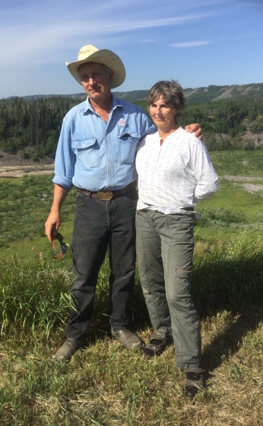
The next day, we travelled east from Hudson’s Hope along the valley to Bear Flat to see farmers Arlene and Ken Boon, whose land is due to be flooded. It’s pretty clear where they stand: the sign at the entrance to their farm says “Site C sucks” and the yellow protest stakes on the property raise money for West Moberly’s legal challenge.
Arlene was canning beans and Ken was working in the hay fields that day. They stopped work to welcome us and show us around. In Cache Creek far below, three bucks walked sedately along a path in the morning haze. Swallows swooped, swirled and chattered overhead. A light breeze rustled the poplar trees nearby.
On the far side of Cache Creek, not to be confused with the town of the same name, sandstone cliffs led to a treed plateau, where the Boons have a campground, now closed, and a sweat lodge surrounded by sacred land.
Behind their modest house, formerly Arlene’s grandfather’s, a series of renovated historic cabins are a tribute to Ken’s carpentry and construction skills. In front, a harvested hay field runs down to Highway 29, and in the bottom field, corn and alfalfa crops lead to a broad vista of the Peace River.
“If we get kicked out, where would we move to that’s more beautiful than this?” asked Ken rhetorically.
Most of the land they live on is already owned by B.C. Hydro, including their house, which was expropriated in December 2016. Where once they owned 469 acres, now they have just 73 acres remaining up the hill and 9.4 acres near the house, plus leased land they share with family members.
“We rent the land back from B.C. Hydro for a dollar, but I haven’t given them it and I’m not going to,” said Arlene.
It’s been a yo-yo ride for the Boons. Initially, they were told they’d lose everything. Then they were assured they’d lose most but not all the land. Now they’ve been told they may be able to buy some of the land back, depending on the final route chosen for the relocated Highway 29.
“It’s a total screw-up of our lives,” Ken said. “But we’ll pick up the pieces and go on from there.”
Arlene is one of five children born and raised up the hill and she’s lived all her life in the Peace region and raised her sons here. All five siblings still live in the area, and four own farmland. Their mother Caroline Bentley, who’d lived in Bear Flat since 1959, moved into the renovated Bear Flat Schoolhouse on Ken and Arlene’s property after he died. When all the uncertainty and talk of expropriation began, she decided to move to nearby Fort St. John.
Arlene got married at 16 and moved with her first husband to Taylor, near Fort St. John. Later, they moved into Fort. St. John itself but she returned to Bear Flat. She met Ken in the mountains when he was guiding and she went up to cook for the summer. He’s been here since 1990 and is now president of the Peace Valley Landowners Association.
The couple were at the forefront of the Rocky Mountain Fort protest camp two and a half years ago and say the one good thing to come out of this fight is their friendship with local First Nations.
“It’s changed for us amazingly,” said Arlene. “This has brought us together: understanding who they are and what’s happened to them.”
The Site C project received environmental approval from the federal and the B.C. Liberal government in October 2014, and work began in the summer of 2015.
In March 2017, they watched as contractors for B.C. Hydro cleared their expropriated lands at Cache Creek by mulching all the trees. They are critical of the waste of valuable lumber.
“The problem with Site C is they’re given all these environmental exemptions and they just do what they want to do, and the enforcement guys are understaffed,” said Ken Boon.
The current NDP/Green coalition government took office in the summer of 2017 and Premier John Horgan, who was against the project while in opposition, ordered a project review by the B.C. Utilities Commission. The Boons began to hope again.
When they read the inquiry report, they were sure the Site C project would be stopped, as it concluded Site C could face more delays and that B.C. Hydro may have overestimated future power needs.
But in December 2017, Horgan approved the project. His rationale was that Site C was already 25 percent complete before his party took office, and that it had gone too far to stop it. The Boons were baffled and dismayed.
“We’re still stunned,” said Ken.
As part of the approval process, the NDP said it would work with Treaty 8 Nations to realign Highway 29 at Bear Flat to reduce the effects on historic burial sites and sacred places. The Boons have been told one of three routes will be chosen shortly.
Bringing the court case
West Moberly First Nations, after losing an earlier court case, filed suit in January this year only after the NDP government gave the go-ahead for Site C.
“Our focus is on trying to save the valley,” West Moberly chief Roland Willson explained in a phone interview. “We thought Horgan was going to honor it but he turned tail and ran the other way.”
While Premier Horgan claimed that more than 25 percent of the dam project had been built, Willson said their expert put Site C as only 10-12 percent complete. The project is already two years behind schedule, he added.
He also disputed B.C. Hydro’s claim that it would cost $2 billion to reclaim the land already cleared. “That’s a pile of nonsense. It’s just fearmongering,” he said.
“There are better options than Site C. There’s no pressure or need to have this energy. It’s a political decision, but it has a huge environmental footprint.”
B.C. Hydro: stopping Site C would be “massive disaster”
I dropped in on the B.C. Supreme Court hearing in Vancouver at the beginning of August for a couple of afternoon sessions. Justice Warren Milman was hearing testimony from lawyers representing B.C. Hydro at the time.
Mark Andrews of the law firm Fasken Martineau DuMoulin argued that most of West Moberly’s hunting, fishing, trapping, and other traditional uses were not at the site of the new reservoir. He also stated that there were many other places outside this area for the First Nations to exercise their Treaty rights and that there was no risk they would suffer irreparable harm because of Site C.
Attorney Bridget Gilbride later discussed the effects on wildlife in the region, saying the Site C area was not a key one for caribou and would have no effect on the caribou population.
She also disagreed with the West Moberly plaintiffs that the moose population was at an all-time low, saying the Peace River supported a large, stable or increasing moose population. While the project is predicted to decrease the moose population by 300 (due to loss of habitat) she argued the area would continue to support a large moose population.
She agreed that once the reservoir was built, it may become a barrier in winter to moose, elk, mule and white-tailed deer, but added that the river was already a barrier. In summer, the reservoir would be narrow and clear-cutting was planned before flooding, so the animals could still swim across it without encountering debris.
The following afternoon, BC Hydro’s lawyer Mark Andrews said that halting construction on the dam would be “a massive disaster.”
He said about 200 contracts were currently locked in, valued at $6 billion Canadian. BC Hydro estimated a full project stoppage for two years would cost an extra $1.44 billion and a three-year stoppage, $1.86 billion. Contractors would be shut down and workers laid off.
“The project is well under way—the public interest is that this project proceed,” he added.
Alternatives to Site C
If the project is stopped, a key question then has to be: “What are the alternatives?”
This is a huge topic in itself, but in its 308-page report last November, the B.C. Utilities Commission received many suggestions at length. These were the three main themes:
- Increasing efficiencies by using more aggressive demand-side management initiatives, such as peak pricing and industrial demand curtailment.
- Increasing supply from existing infrastructure—for example, the Columbia River Treaty dams, Burrard Thermal, and existing dam retrofits.
- Alternative renewable supply projects, such as wind, solar, and thermal energy.
Visiting the construction site
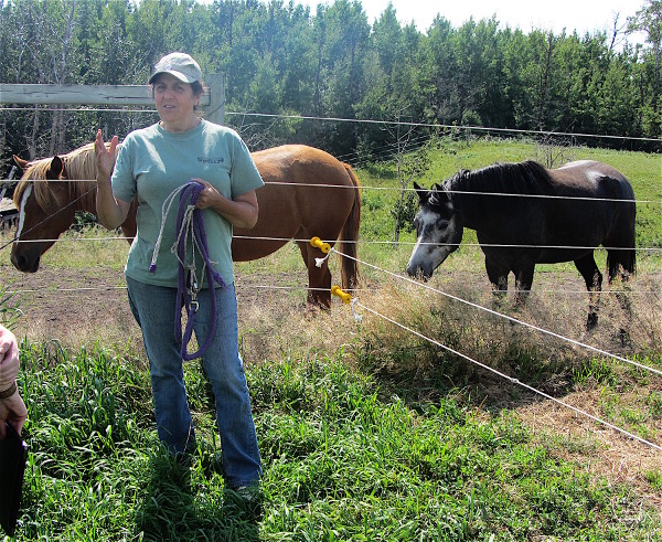
Now it was time to visit the dam site itself. B.C. Hydro has its own public viewing area but locals weren’t sure it was open so we went to Esther and Poul Pedersen’s horse and hay farm instead. They live directly above the site and have access to a great viewpoint from the north bank, known as “Protesters’ Point.”
Twenty minutes down the road from the Boons, close to the unappealing sprawl of Fort St. John, we turned off Highway 97 and headed down a dead-end road. Away from the busy highway, the scene immediately turned pastoral. As we pulled up to the Pedersen’s home, a bevy of friendly dogs and cats surrounded us. One cat climbed into my car.
Esther Pedersen emerged and as one of the cats snuggled with a Guardian dog she told the story of how the cat got lost for several months on a neighboring property. The dog kept disappearing to visit regularly and one day led the lost cat back to their farm. They’ve been lifelong friends ever since.
Before taking us to see Site C, she let out one of the mares and her skittish foal from their pens to feed. The Pedersens used to run a dairy farm nearby and this farm formerly belonged to Poul’s father. They moved here in 2002 and now breed, train and sell registered Canadian Warmblood horses and ponies.
Due to Site C, their plans for an indoor riding arena are now on hold. More than half of their lands, including their home, are behind the Stability Impact lines and no permanent structures can be built behind or between the lines and the river’s edge.
“This waiting is the hardest part. This is where we want to live but we’re in this Neverland,” said Esther. “A lot of really bad politics have happened here.”
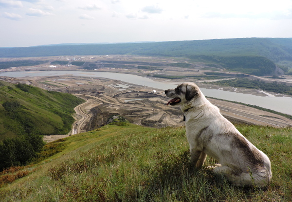
We walked along a path past bushes, grazing land and hay fields until we reached the river’s edge. Then we made our way on to crown land and up to a cabin nicknamed the Dam Protesters’ Shack. To the right, the Peace River looks largely untouched. But on the left, far below, it’s a very different story.
Mud was everywhere, with layers and layers of levelled mud separated by dirt roads on both sides of the river, and heavy machinery dotted around. But not much concrete work was in sight and I had to ask where the dam itself would be.
“Where’s the dam?” I wondered, looking at the unimpeded river.
Esther pointed out the intended spot, saying: “There’s no dam here. There’s nothing but dirt. This is the time to stop, before they put in the diversion tunnel.”
Dave Conway, B.C. Hydro’s community relations manager for the project, said however that a lot of the work isn’t visible from the north side. He couldn’t put a percentage figure on the amount of work done but said the first generator is scheduled to go online in 2024.
Speaking on Aug. 31, Conway said work had just started on the two diversion tunnels, due to be completed by 2020, and work on the coffer dam has also started.
The project calls for an earthfill dam, approximately one kilometre long and 60 metres high above the riverbed and a generating station with six 183 MW generating units.
Esther is concerned about the safety of the dam, saying: “This damn hill keeps falling in. The geology in this valley is Shaftesbury shale, gravel, and monolithic clay. It’s a clay valued worldwide by potters because when it’s exposed to water it becomes liquid.”
But Conway, the community relations manager for the project, said B.C. Hydro has been onsite since the 1970s and drilled hundreds of core holes, so they are very familiar with the geology. The dam is going to rest on shales, he added.
“The shale is the bedrock,” he added. He said the 2011 project description in the environmental assessment made this clear and there has been no change in the original plan.
What does the future hold for Peace Valley?
So now the waiting game continues for those in the valley until Justice Warren Milman makes his court ruling on the West Moberly injunction, likely later this year.
“I believe myself if this injunction happens, it’s a sign of huge hope,” said Esther Pedersen.
And if it isn’t successful?
“I think the river will decide what happens.”
We met Yvonne Tupper in Chetwynd once more before heading south down the long drive back to Vancouver.
She shared with me these final thoughts: “I was born and raised in construction, but this is too much. I want all this industry to slow down and let the land heal. Then the people can heal and know they matter.”
Photo credits: view of Peace River, Yvonne Tupper in the woods and Esther Pedersen’s dog above Site C dam are by Jennifer O’Keeffe. All others are by Alison Bate.
Alison Bate is an experienced journalist and former magazine editor based in Vancouver, B.C. She worked at The Vancouver Sun for nine years, and before that on newspapers in England. Her website is http://alisonbate.ca